예보는 내일이 맑을지 폭풍이 몰아칠지를 잘 알려줍니다. 그러나 해변에서 중요한 해상도, 즉 아침 수영 시간이 두 시간 동안 지속될지 아니면 해안 뒤에서 무언가가 다가오는지를 예측하는 데는 덜 효과적입니다. 해안 근처에서 많은 시간을 보내는 사람들은 하늘을 직접 읽는 법을 배우며, 이 기술은 예보와 실제 상황 간의 간극을 좁혀줍니다.
이 가이드는 예보를 대체하는 것이 아닙니다. 해변 시간이 열리거나 닫히는지를 결정하는 데 도움이 되는 세 가지 또는 네 가지 시각적 단서를 추가하는 것입니다. NOAA의 구름 가이드와 기본 대기 과학이 대부분의 작업을 수행하며, 나머지는 긴 드라이브를 시작하기 전에 주의를 기울이는 것입니다.
- 아침 동안 커지는 구름은 여름철 오후 폭풍 경고의 전형적인 신호입니다.
- 하늘에 얇고 높은 구름(시러스)이 하루 종일 두꺼워지면 보통 12~24시간 이내에 날씨가 다가오고 있음을 의미합니다.
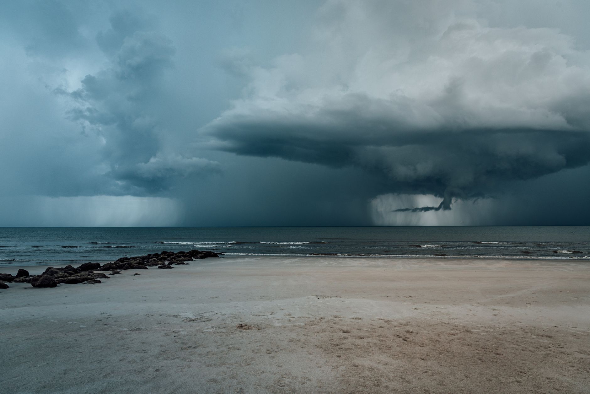
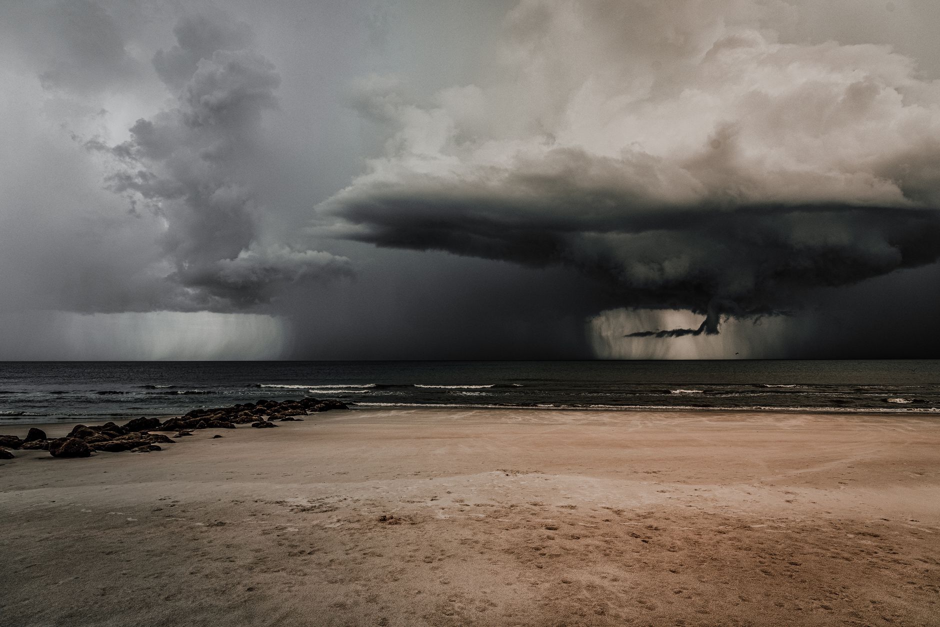
- 수평선에 뚜렷한 어두운 선이 보이면 그것은 돌풍 전선입니다: 도착하기 전에 물에서 나와야 합니다.
- 무더운 오후에 고요하고 흐릿한 저시정 공기는 종종 내륙에서 천둥번개가 발생하기 전의 신호입니다.
하루를 바꾸는 세 가지 구름 유형
NOAA의 제트스트림 구름 가이드는 구름을 고도와 형태에 따라 분류합니다. 해변 계획에 중요한 세 가지 구름 가족은 시러스(높고 가는 얼음 구름), 큐뮬러스(부풀어 오른 낮은 중간 구름) 및 적란운(완전히 발달한 폭풍)입니다. 이를 인식하는 데 전문 교육은 필요하지 않으며, 몇 가지 정신적 기준만 있으면 됩니다.
시러스 구름은 하늘 높이 있는 가는 흰 줄처럼 보이며, 때때로 '말꼬리'라고 불리는 섬유질 질감을 가지고 있습니다. 큐뮬러스 구름은 솜사탕 같은 구름으로, 바닥은 평평하고 위는 둥글게 되어 있습니다. 적란운은 큐뮬러스가 몇 시간 동안 수직으로 성장하여 망치 모양의 꼭대기를 가진 높은 탑으로 성장한 것입니다. 각각은 다른 메시지를 가지고 있습니다.
- 시러스 두꺼워짐: 12~24시간 이내에 날씨 변화 예상.
- 아침 내내 커지는 큐뮬러스: 오후 중반에서 늦은 오후에 천둥번개 위험.
- 망치 모양의 적란운: 폭풍이 성숙했으니 물에 있거나 근처에 있지 마세요.
아침 하늘이 오후 이야기를 전한다
가장 유용한 하늘 관찰 시간은 아침입니다. 아침 9시부터 11시까지 하늘이 파랗고 작은 평평한 큐뮬러스가 대체로 같은 크기를 유지한다면, 그 날은 안정적이며 해변 계획이 안전합니다. 같은 큐뮬러스가 매시간 눈에 띄게 커지고 있다면, 대기는 불안정하며 그 날 오후에 천둥번개가 발생할 확률이 급격히 상승합니다.
이 패턴은 특히 따뜻한 내륙이 있는 해안 근처에서 여름철에 신뢰할 수 있습니다: 남부 프랑스, 이탈리아, 발칸 반도, 그리스 섬, 미국 동부 해안. 바다 바람이 습한 공기를 내륙으로 끌어올리며, 그곳에서 상승하고 응결됩니다. 아침의 작은 큐뮬러스가 중간 오후의 높은 큐뮬러스로 변하는 것은 교과서적인 순서입니다. NOAA는 내륙에서 발생한 천둥번개가 오후 늦게 바람과 함께 해안에 도착하는 경우가 많다고 언급합니다.

색상과 움직임: 빠르게 반응해야 할 것들
몇 가지 시각적 단서는 몇 분 안에 결정을 바꿔야 합니다. 수평선에 뚜렷한 어두운 선이 보이면, 종종 녹색 또는 슬레이트 회색으로, 그것은 천둥번개 세포에 의해 밀려나온 돌풍 전선입니다. 그것은 비가 내리기 30~60분 전에 도착할 수 있습니다. NOAA의 폭풍 안전 지침은 명확합니다: 만약 하나를 보게 된다면, 물에서 나와 도착하기 전에 대피소를 찾으세요.
다른 빠른 신호로는 무더운 날에 갑작스러운 차가운 공기(형성 중인 세포의 하강 흐름), 심한 안개 속에서 노란색 또는 구리색 하늘(종종 먼지나 연기), 그리고 멀리서 갑자기 떨어지는 낮은 하늘(비 기둥)이 있습니다. 이들은 미묘하지 않습니다. 그것들은 오후 중반의 시각적 경고이며, 아침의 긍정적인 예보를 무시해야 합니다.
하늘을 나머지 데이터와 함께 사용하세요
하늘을 읽는 것은 실용적인 기술이지 마법이 아닙니다. 그것은 BeachFinder가 스팟 페이지에서 보여주는 바람, 파도, UV, 수온 및 수질 정보와 함께 사용할 때 가장 잘 작동합니다. 커지는 큐뮬러스, 느린 남풍, 높은 UV가 있는 아침은 안정적인 큐뮬러스, 일정한 바람, 낮은 습도가 있는 아침과는 다른 결정을 의미합니다.
BeachFinder를 사용하여 사진, 지도, 날씨, UV, 수온, 바람, 파도, 흐름, 수질(가능한 경우), 편의 시설, 숙박 및 활동을 비교한 후 여행을 결정하세요.
- Dark horizontal line on the horizon: gust front coming.
- Sudden cool air drop on a hot afternoon: downdraft from a nearby cell.
- Vertical 'rain shaft' visible offshore: storm is precipitating, may move toward you.
Calm haze on a hot day is not always relaxing
On hot summer afternoons in the Mediterranean and US Southeast, the air can become very calm, hazy and low-visibility. People often assume this is the best swim window because nothing seems to be happening. In practice it is sometimes the worst window: still air with high humidity and surface heating is exactly the recipe for late-afternoon thunderstorm formation just inland. The beach can stay sunny while a cell builds 20 km behind the cliffs.
If the morning had cumulus growth and the afternoon turns into still hazy heat, treat that as a yellow flag for the day's tail end. The forecast may say 30 percent storm chance, which sounds low, but the local terrain can concentrate it on a specific stretch of coast.
Use the sky next to the rest of the data
Reading the sky is a practical skill, not magic. It works best alongside the wind, swell, UV, water temperature and water quality information BeachFinder shows on the spot page. A morning with growing cumulus, a slow southerly wind and high UV is a different decision than a morning with stable cumulus, a steady offshore wind and lower humidity.
Use BeachFinder to compare the photo, map, weather, UV, water temperature, wind, waves, currents, water quality where available, amenities, stays and activities before committing to the trip.
출발 전 체크
- Look up at 9 a.m. and 11 a.m. and compare cumulus size.
- If high thin cloud is thickening across the morning, expect weather change within 24 hours.
- Leave the water immediately if you see a sharp dark line on the horizon.
- Treat sudden cool gusts on a hot afternoon as a storm cue, not relief.
- Pair what you see with the spot page wind, UV and waves before deciding.
FAQ
Can I really predict storms by looking at clouds?
You can detect the obvious cases: morning cumulus growing into towers usually means afternoon thunderstorms, and a sharp dark line on the horizon is almost always a gust front. You will not predict subtle frontal weather, which is what national agencies are for. The point is to add a fast visual layer, not replace the forecast.
What does a halo around the sun mean?
A halo is caused by ice crystals in cirrostratus clouds. It often signals an approaching warm front in the next 12 to 24 hours, which can mean rain or wind change is on the way. It does not predict thunderstorms directly, but it is a slow-signal indicator the day after may be different.
Is calm hot afternoon air a good beach signal?
Not always. In summer, calm humid heat with growing inland cumulus is one of the classic setups for late-afternoon thunderstorms. The beach itself may remain sunny while a cell builds inland. Watch the horizon and any growing tower over land.
BeachFinder로 오늘의 스팟을 확인하세요.
현재 위치, 전 세계 도시 검색 또는 지도를 사용해 주변에서 가장 관련성 높은 수영 스팟 20곳을 비교하세요.
These beach pages connect the guide advice with real spot details: sea temperature, wind, UV index, waves, access and photos when available.
Beach Baia Blu
IT
Hakuna Matata Beach
IT
Sunset Beach Club Palinuro
IT
Plage Gazagnaire
IT
Plage Rive Gauche
FR
Plage de la Dalle
FR
Plage de Saint-Jean
FR
Grande Blue Beach
TR
Spiaggia grande di Tordigliano
IT
Baia dei Mergoli o delle Zagare - Nord
IT
Plage du Lividic
FR
Plage de Notre-Dame
FR
David
FR
Plage du Moulin Brûlé
FR
Spiaggia di Marina d'Albori
IT