Reading the sky and clouds before a beach trip
Visual cues from cloud type, color and motion that often predict the beach window better than the forecast does.
Forecasts are good at saying whether tomorrow will be sunny or stormy. They are less good at the resolution that matters at the beach: will the morning swim window hold for two hours, or is something building behind the headland? People who spend a lot of time near the coast learn to read the sky directly, and that skill closes the gap between the forecast and what actually happens.
This guide is not about replacing the forecast. It is about adding three or four visual cues that help you decide whether the beach window is widening or closing. NOAA's cloud guide and basic atmospheric science do most of the heavy lifting; the rest is paying attention before you commit to a long drive.
- Cumulus growing taller through the morning is the classic afternoon-storm warning, especially in summer.
- High thin clouds (cirrus) that thicken across the day usually mean weather is approaching within 12 to 24 hours.
- A sharp dark line on the horizon is a gust front: get off the water before it arrives.
- Calm, hazy, low-visibility air on a hot afternoon often precedes thunderstorms inland.
Three cloud types that change the day
NOAA's JetStream cloud guide groups clouds by altitude and shape. For beach planning, three families matter: cirrus (high, wispy, ice clouds), cumulus (puffy, low to middle clouds with vertical growth) and the cumulonimbus tower (a fully developed storm). Recognizing them does not require expert training, just a few mental anchors.
Cirrus clouds look like fine white streaks high in the sky, often with a fibrous texture sometimes called 'mares' tails'. Cumulus clouds are the cotton-ball clouds, flat-bottomed and rounded on top. Cumulonimbus is the cumulus that has grown into a tall tower with an anvil-shaped top, usually after several hours of vertical buildup. Each has a different message.
- Cirrus thickening: weather change in 12 to 24 hours.
- Cumulus growing all morning: thunderstorm risk by mid to late afternoon.
- Anvil-topped cumulonimbus: storm is mature; do not be on or near the water.
Morning sky tells the afternoon story
The most useful sky window is the morning. If the sky is blue with small flat cumulus that stay roughly the same size from 9 a.m. to 11 a.m., the day is stable and the beach plan is safe. If the same cumulus are visibly growing taller every hour, the atmosphere is unstable and the chance of a thunderstorm later that day rises sharply.
This pattern is especially reliable in summer near coastlines with warm interiors: southern France, Italy, the Balkans, Greek islands, the US East Coast. The sea breeze pulls moist air inland, where it rises and condenses. Morning small-cumulus turning into mid-afternoon towering-cumulus is the textbook sequence. NOAA notes that thunderstorms over land often arrive at the coast in the late afternoon along with the breeze return.

High thin clouds: the slow signal
Cirrus clouds often arrive 12 to 24 hours before a frontal system. On their own they are not a problem, but their behavior matters. If the morning starts with a few wispy cirrus and the sky stays mostly blue, the day is usually fine. If those streaks thicken, lower into a milky gray sheet (cirrostratus) and finally turn into a flat dull layer (altostratus), a front is approaching and the beach window is closing.
This is the slow signal. It will not change your morning plan but it will warn you that tomorrow may be different. The classic seasonal example is the Cote d'Azur or Sardinia at the front edge of an autumn front: blue Monday, hazy Tuesday with cirrus, gray Wednesday, rain Thursday.
Color and motion: what you should react to fast
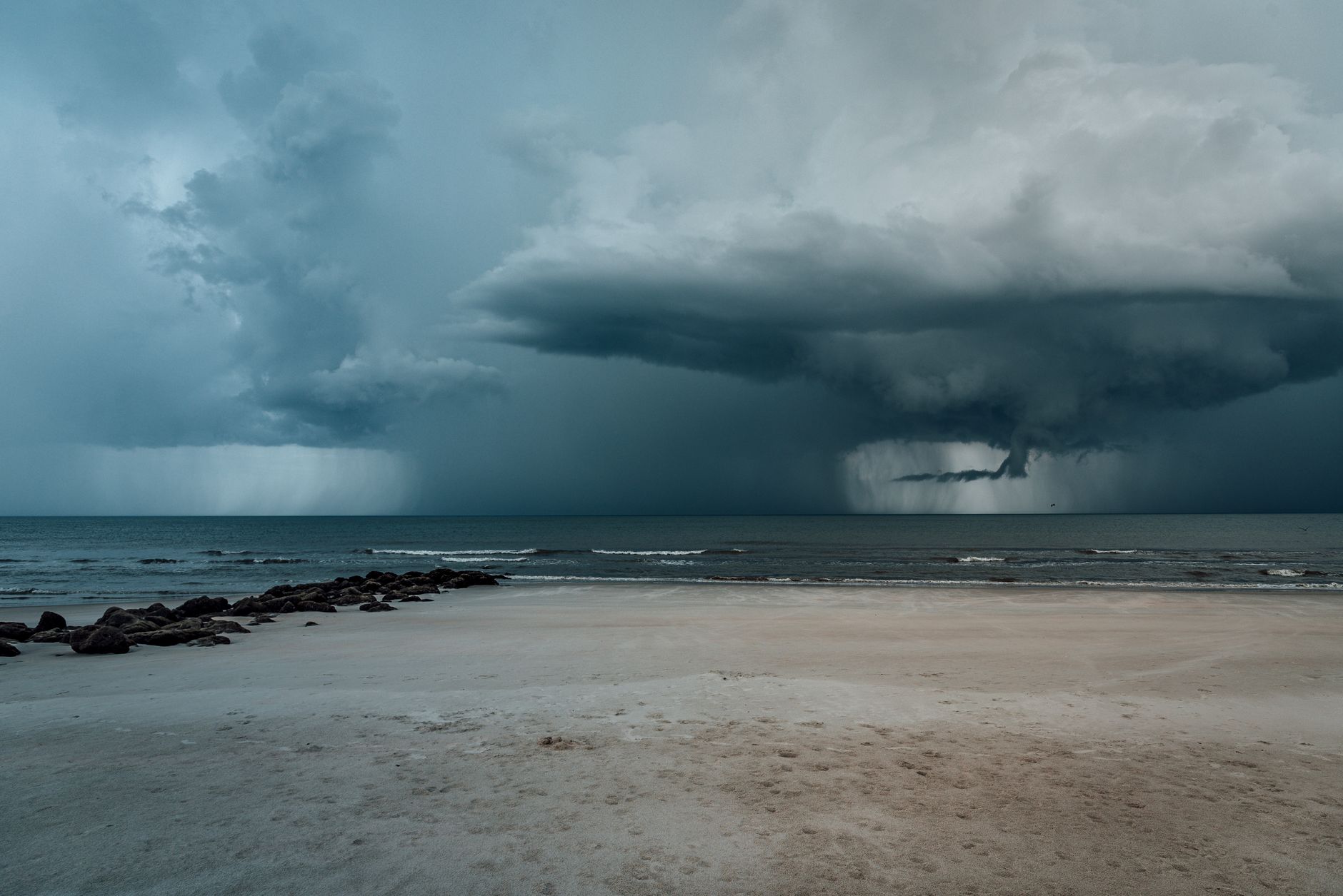
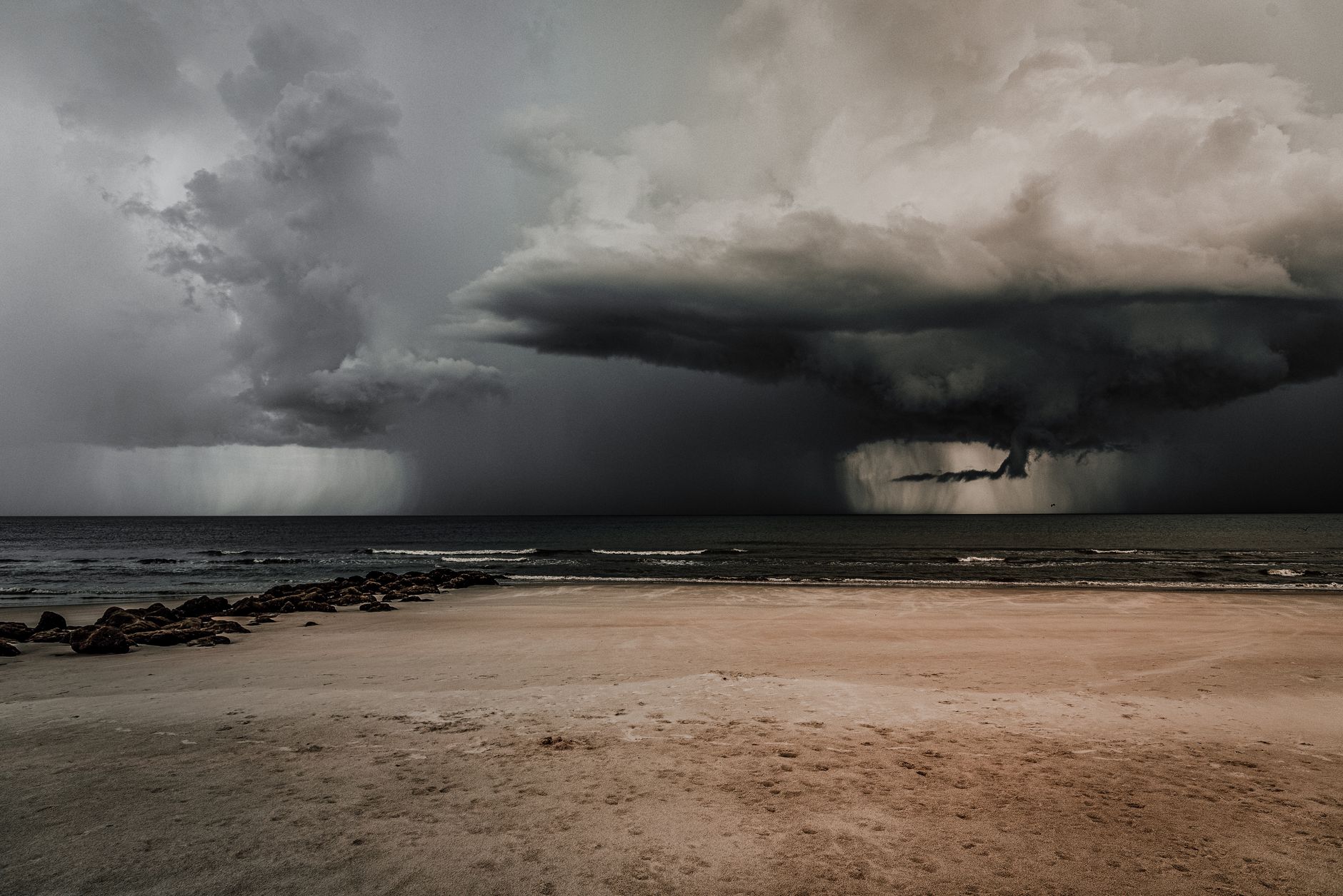
A few visual cues should change your decision in minutes, not hours. A sharp dark line on the horizon, often greenish or slate gray, is a gust front pushed out by a thunderstorm cell. It can be 30 to 60 minutes ahead of the rain itself. NOAA's storm safety guidance is clear: if you see one, leave the water and find shelter before it arrives.
Other rapid cues include sudden cooling air on a hot day (a downdraft from a building cell), a yellowish or coppery sky during heavy haze (often dust or smoke), and a low sky that suddenly drops in the distance (a rain shaft). None of these are subtle. They are mid-afternoon visual alerts, and they should override the morning's positive forecast.
- Dark horizontal line on the horizon: gust front coming.
- Sudden cool air drop on a hot afternoon: downdraft from a nearby cell.
- Vertical 'rain shaft' visible offshore: storm is precipitating, may move toward you.
Calm haze on a hot day is not always relaxing
On hot summer afternoons in the Mediterranean and US Southeast, the air can become very calm, hazy and low-visibility. People often assume this is the best swim window because nothing seems to be happening. In practice it is sometimes the worst window: still air with high humidity and surface heating is exactly the recipe for late-afternoon thunderstorm formation just inland. The beach can stay sunny while a cell builds 20 km behind the cliffs.
If the morning had cumulus growth and the afternoon turns into still hazy heat, treat that as a yellow flag for the day's tail end. The forecast may say 30 percent storm chance, which sounds low, but the local terrain can concentrate it on a specific stretch of coast.
Use the sky next to the rest of the data
Reading the sky is a practical skill, not magic. It works best alongside the wind, swell, UV, water temperature and water quality information BeachFinder shows on the spot page. A morning with growing cumulus, a slow southerly wind and high UV is a different decision than a morning with stable cumulus, a steady offshore wind and lower humidity.
Use BeachFinder to compare the photo, map, weather, UV, water temperature, wind, waves, currents, water quality where available, amenities, stays and activities before committing to the trip.
Before you go
- Look up at 9 a.m. and 11 a.m. and compare cumulus size.
- If high thin cloud is thickening across the morning, expect weather change within 24 hours.
- Leave the water immediately if you see a sharp dark line on the horizon.
- Treat sudden cool gusts on a hot afternoon as a storm cue, not relief.
- Pair what you see with the spot page wind, UV and waves before deciding.
FAQ
Can I really predict storms by looking at clouds?
You can detect the obvious cases: morning cumulus growing into towers usually means afternoon thunderstorms, and a sharp dark line on the horizon is almost always a gust front. You will not predict subtle frontal weather, which is what national agencies are for. The point is to add a fast visual layer, not replace the forecast.
What does a halo around the sun mean?
A halo is caused by ice crystals in cirrostratus clouds. It often signals an approaching warm front in the next 12 to 24 hours, which can mean rain or wind change is on the way. It does not predict thunderstorms directly, but it is a slow-signal indicator the day after may be different.
Is calm hot afternoon air a good beach signal?
Not always. In summer, calm humid heat with growing inland cumulus is one of the classic setups for late-afternoon thunderstorms. The beach itself may remain sunny while a cell builds inland. Watch the horizon and any growing tower over land.
Use BeachFinder to check today's spot.
Use your location, search any city worldwide or explore the map to compare the 20 most relevant beaches and swimming spots around you.
These beach pages connect the guide advice with real spot details: sea temperature, wind, UV index, waves, access and photos when available.
Beach Baia Blu
IT
Hakuna Matata Beach
IT
Sunset Beach Club Palinuro
IT
Plage Gazagnaire
IT
Plage Rive Gauche
FR
Plage de la Dalle
FR
Plage de Saint-Jean
FR
Grande Blue Beach
TR
Spiaggia grande di Tordigliano
IT
Baia dei Mergoli o delle Zagare - Nord
IT
Plage du Lividic
FR
Plage de Notre-Dame
FR
David
FR
Plage du Moulin Brûlé
FR
Spiaggia di Marina d'Albori
IT