Best beaches on the Cote d'Azur: from Nice to Saint-Tropez
Riviera beach overview from Nice and Cannes to Saint-Tropez, with pebble versus sand reality, Posidonia, mistral impact and concession logistics for first-time visitors.
The Cote d'Azur is the most photographed coastline in France and one of the most misread. Travelers arrive expecting Caribbean sand and discover a thirty-kilometer strip of grey pebbles in Nice. They look for an empty cove and find Pampelonne booked out by 11:00. They picture a flat Mediterranean and meet a mistral that ruffles the bay for three days running. None of this means the Riviera is overrated; it means the coastline rewards travelers who know which town has which kind of beach and how the local wind, the Posidonia meadows offshore and the concession economy reshape the day.
Use this guide as the regional map between five anchor towns: Nice, Villefranche, Antibes, Cannes and Saint-Tropez. Each owns a distinct beach personality, and the choice between them is rarely about distance. A first-time family is happier at Plage de la Garoupe in Antibes than fighting for shade on the Croisette. A pair of friends with a rental car finds the Cap d'Antibes coves and the Esterel calanques rather than queueing for Pampelonne. And a calm-water swimmer reads the Meteo-France wind index before deciding which face of the cape to choose.
- Nice and Villefranche are pebble beaches; soft sand starts west of Cannes and continues to Saint-Tropez.
- Posidonia seagrass meadows offshore mean clear water but occasional dead-leaf banks washed up on the sand.
- Mistral winds blow from the north-northwest and shut down east-facing beaches more than south-facing ones.
- Summer water sits around 22 to 26 degrees Celsius from June to early October; June and September are the comfort sweet spots.
Nice, Villefranche and the eastern pebble coast
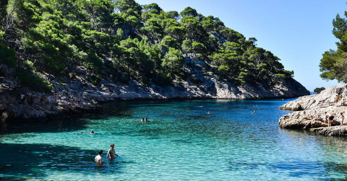
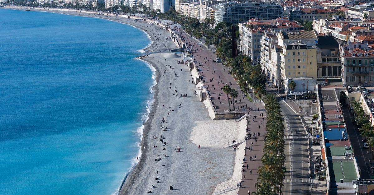
From Nice eastward to the Italian border, the Riviera is a pebble coastline. The Promenade des Anglais runs above a chain of public stretches (Plage Publique de Beau Rivage, Plage de Carras, Plage des Ponchettes) interspersed with private concessions. The water is famously clear because Posidonia meadows filter the sediment, but the pebbles are real and water shoes are not a luxury here. Villefranche-sur-Mer is the small-bay alternative ten minutes east, with a curved harbour beach (Plage des Marinieres) and the sand-and-pebble Plage de la Darse tucked behind the citadel.
Further east, Cap-Ferrat hosts the more intimate Plage de Passable and Plage de Paloma, both pebbles with crystal water and a quieter feel than central Nice. Beaulieu-sur-Mer adds Plage de la Petite Afrique, a tiny crescent below the railway. Treat the eastern half of the Riviera as the cleaner-water, walking-on-stones half, and pack a pair of aqua shoes rather than fight the geology.
- Plage Publique de Beau Rivage (Nice): free public stretch on the Promenade, pebbles, full services nearby.
- Plage des Ponchettes (Nice): below the old town, short walk from Cours Saleya, popular at sunset.
- Plage des Marinieres (Villefranche-sur-Mer): curved bay, train station next door, family-friendly.
- Plage de Passable (Cap-Ferrat): pebble cove, sheltered from mistral, excellent water clarity.
- Plage de Paloma (Cap-Ferrat): pebble, intimate, walk from the lighthouse path.

Antibes and the Cap: the family sweet spot
Antibes is where the Riviera changes character. Plage de la Salis is the long, sandy public beach with a soft slope and a view of the old town ramparts: it is the strongest family default east of Cannes. Plage de la Garoupe sits on the Cap d'Antibes itself, with finer sand, calmer water on the leeward side and the famous Sentier du Littoral coastal path leading there. Plage du Ponteil and Plage du Fort Carre cover the in-town options.
Juan-les-Pins, on the Cap's western side, is the sand and nightlife twin to Antibes. Several private concessions (Belles Rives, Eden Beach) line a long sandy crescent and the water is calm because the bay opens to the southwest. The Cap d'Antibes coastal path links Garoupe to Plage des Ondes and Plage de la Joliette: small free coves the cars do not reach, perfect for a half-day on foot.
Cannes, the Esterel and the western sand
Cannes has the Riviera's most famous promenade and a complicated beach grid. La Croisette is largely concessions in front of the palace hotels; the public stretches are Plage du Midi and Plage de la Bocca west of the Palais des Festivals, plus the small Plage Macet. The sand is finer than Nice and the water is calmer because the Iles de Lerins shelter the bay. For a real island day, the ferry to Sainte-Marguerite reaches Plage du Dragon and the rocky inlets around the Fort Royal in twenty minutes.
West of Cannes, the Massif de l'Esterel begins. Theoule-sur-Mer, Mandelieu-La Napoule, Agay and Anthor host small ochre-cliff coves: Plage du Pradayrol, Plage du Debarquement, Plage d'Anthor and Plage de la Figueirette. The water turns blue against the red rocks and the parking is more relaxed than Cannes itself. Saint-Raphael and Frejus then deliver long sandy beaches (Plage du Veillat, Plage de Saint-Aygulf) that are the strongest family option of the whole western half.
- Plage du Midi (Cannes): public stretch west of the Palais, sand, free.
- Plage du Dragon (Sainte-Marguerite): twenty-minute ferry, pine-shaded, quieter.
- Plage du Debarquement (Anthor): small Esterel cove with red cliffs, free parking off-season.
- Plage du Veillat (Saint-Raphael): long sandy crescent, family default in summer.
- Plage de Saint-Aygulf (Frejus): sand, dunes, calm at high tide.
Saint-Tropez and the Var coves
Saint-Tropez itself has tiny in-town beaches (Plage de la Bouillabaisse, Plage des Graniers, Plage de la Ponche) and one major sandy stretch on the south side of the peninsula: Pampelonne. Plage de Pampelonne is five kilometres long, alternates between free public sections and famous concessions (Club 55, Nikki Beach, Tahiti), and it is the busiest sand in France in August. The realistic plan is early arrival, a reservation if you want a concession lounger, and a walk to the Tahiti or Tropezina sections for a calmer mid-beach feel.
South of Saint-Tropez, the Var continues with Ramatuelle, Gigaro and Cavalaire-sur-Mer, then runs into the Domaine du Rayol gardens and the protected stretch around the Iles d'Hyeres. Plage de l'Escalet at Ramatuelle is the small-cove alternative to Pampelonne, with rocks, pines and snorkeling pockets. Further along, Le Lavandou and Bormes-les-Mimosas host a chain of family beaches (Plage de Cabasson, Plage de la Fossette, Plage de l'Anglade) that absorb crowds without the Saint-Tropez prices.
- Plage de Pampelonne (Ramatuelle): five kilometres, concessions and free sections, fills early.
- Plage de l'Escalet (Ramatuelle): small cove alternative, parking limited, snorkeling.
- Plage des Graniers (Saint-Tropez): tiny in-town, walkable from the port, casual lunch beach.
- Plage de Cabasson (Bormes-les-Mimosas): family default, soft sand, view on Fort de Bregancon.
- Plage de la Fossette (Le Lavandou): pine-shaded cove, calmer crowd.
Climate, mistral and Posidonia: what actually shapes the day
Mediterranean water on the Cote d'Azur warms slowly from a 14 degree winter floor to roughly 18 in May, 22 in June, 24 to 26 in July and August, 23 in September and 20 in October. The full swimming season runs late May to mid-October for most travelers, with June and September the comfort sweet spots between cold spring water and August crowds. UV peaks in July with sustained values of 8 to 10, which makes shade and reapplication non-negotiable.
The mistral is the dominant local wind, blowing from the north or northwest in dry bursts that can last two to four days. South-facing beaches (Antibes, Cannes, Saint-Tropez) shelter behind the coastline and stay swimmable; east-facing pockets like Villefranche or the Cap-Ferrat eastern flank get chop and the lounger umbrellas come down. The Posidonia meadows offshore are the reason the water is so clear, and the brown leaf-banks that occasionally wash up on the sand are not pollution but the natural cycle of the seagrass shedding old fronds.
- Sea temperature peak: 25 to 26 degrees Celsius late July to mid-August.
- Mistral: prefer south-facing beaches, watch the wind forecast 48 hours ahead.
- Posidonia leaves on sand: natural, not pollution; sweep an arm-length spot or move 30 metres along.
- Crowd peak: August Saturdays; June and September deliver the same coast with much less pressure.
Before you go
- Pack water shoes for Nice and the eastern pebble coast; useless west of Cannes.
- Default to Antibes (Salis or Garoupe) for families east of Cannes.
- Reserve a Pampelonne concession or arrive before 10:00 in August.
- Check Meteo-France wind direction the morning before choosing east-facing coves.
- Save a south-facing backup beach for mistral days.
FAQ
Are the beaches in Nice really pebbles?
Yes. The Promenade des Anglais runs above a continuous pebble shoreline that extends east through Villefranche, Beaulieu and Cap-Ferrat. The pebbles are part of the local geology, not a temporary state, and the water is clearer because they generate less suspended sediment than sand. Soft sand begins west of Cannes and continues through the Esterel to Saint-Tropez and the Var. Pack water shoes for the eastern half of the Riviera and you will be comfortable; turn up barefoot expecting Caribbean conditions and you will regret it.
When is the best month for the Cote d'Azur beaches?
June and September are the comfort sweet spots. Sea temperature already reaches 22 degrees Celsius by mid-June and stays around 23 in September, the air is warm but not punishing, UV is manageable and the crowds are roughly half what they are in August. July and August deliver the warmest water (24 to 26 degrees) but bring booked-out parking, full concessions and aggressive mistral episodes that can ruin two days in a row. Plan around the activity: families with school constraints often prefer late June, photographers and slow travelers prefer September.
Do you have to pay to use the Cote d'Azur beaches?
No, public beaches are free everywhere. The Riviera has a mix of free public stretches and paid private concessions (matelas, sun loungers, lunch service). On the same beach you can often walk from a free section into a concession just by moving fifty metres. Famous spots like the Croisette in Cannes or Pampelonne in Saint-Tropez have larger concession footprints, but a free section always exists nearby. The paid sections include towel service, shade and a restaurant; if you carry a towel and a shade tent yourself, no payment is needed to swim.
Use BeachFinder to check today's spot.
Use your location, search any city worldwide or explore the map to compare the 20 most relevant beaches and swimming spots around you.
These beach pages connect the guide advice with real spot details: sea temperature, wind, UV index, waves, access and photos when available.
Plage de Saint-Jean
FR
Plage Rive Gauche
FR
Plage de la Dalle
FR
Baignade biologique
La Chapelle-Saint-Sauveur - FR
Plage de Saint-Colomban
FR
Plage du Lividic
FR
Plage de Notre-Dame
FR
David
FR
Plage du Moulin Brûlé
FR
Plage de La Folie Calette
FR
Plage du Tertre Pelé
FR
Plan d'eau de Chambaud
FR
Grands Sables
FR
Plage des Célestins
FR
Plage de Mousterlin
FR