Como identificar avisos de poluição antes de nadar
O que observar na linha d'água, as regras de tempo em relação à chuva e tempestades, e as fontes oficiais que importam ao decidir se é seguro nadar hoje.

A maioria da poluição nas praias não se anuncia com um aviso. Uma costa pode parecer boa na foto e ainda assim ser um dia ruim para nadar devido a um evento de chuva a montante, um transbordamento de tempestade, uma floração de algas ou um lançamento silencioso de esgoto. O sistema de monitoramento oficial é bom, mas não é em tempo real, o que significa que o nadador deve combinar o painel com o que a praia está mostrando na frente dele.
Este guia é a versão prática dessa decisão. Quais sinais visuais observar na linha d'água, quais regras de tempo se aplicam em relação à chuva e tempestades, e quais fontes oficiais confiar. Nada disso é paranoia; é a mesma cautela que um pescador ou um nadador competitivo aplicaria automaticamente.
- Sinais visíveis importam: espuma, descoloração, cheiro, peixes mortos e água rasa incomumente quente são todos sinais.
- Vinte e quatro a quarenta e oito horas após chuvas fortes é a janela de maior risco na maioria das praias costeiras.
- Os painéis de monitoramento de água de banho oficiais mostram o quadro de longo prazo; eles nem sempre refletem o dia de hoje.
- Quando a praia visível contradiz a bandeira verde oficial, confie na praia à sua frente, não no painel.
Visual cues at the waterline
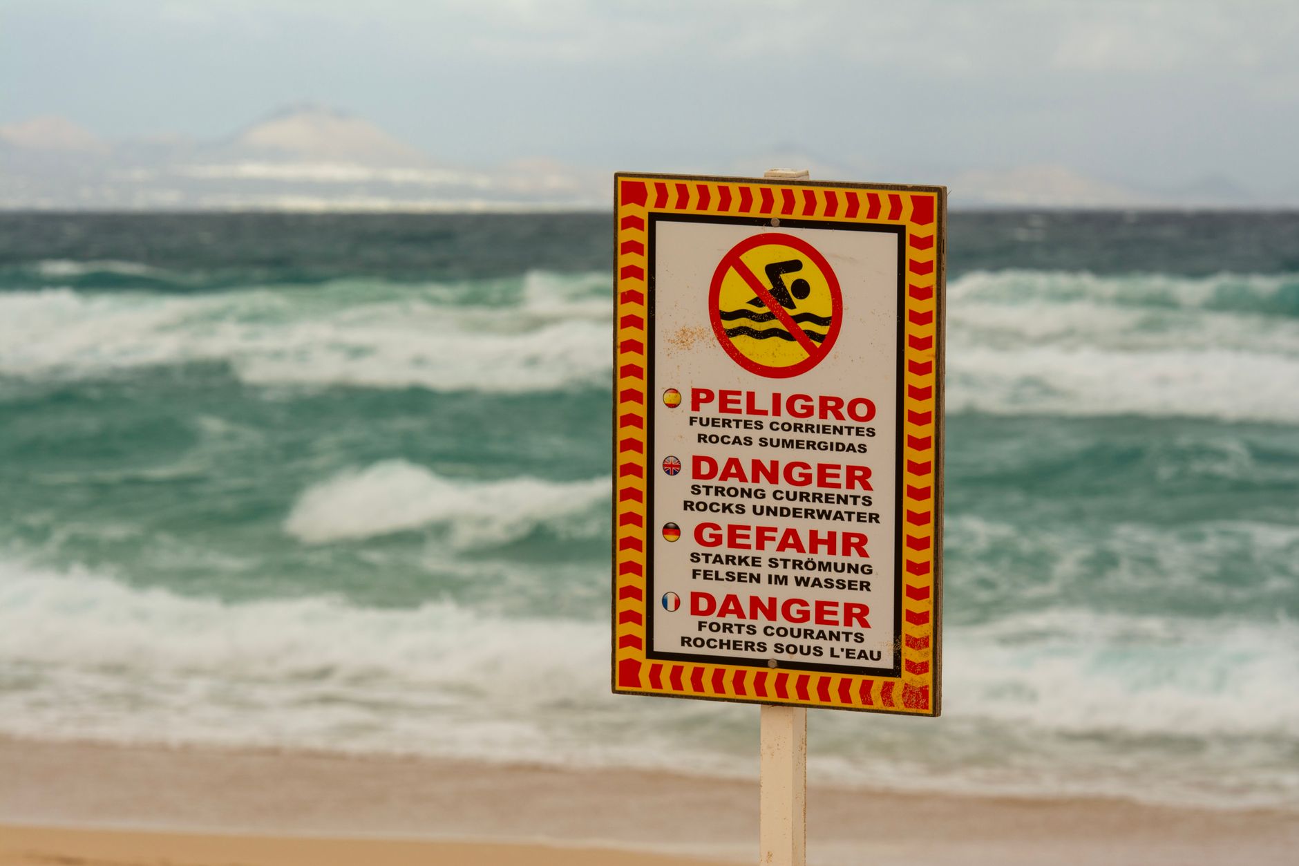
Walk to the waterline before unpacking the bags. Look at the colour of the water in the first ten meters: a healthy shoreline shows a gradient from clear in the shallows to deeper blue or green further out. If the water is uniformly brown, milky, dark green or has visible streaks of orange or red, treat that as a signal even if no warning is posted.
Foam is more nuanced. Sea foam from breaking waves is normal and harmless. Foam that smells, that has yellowish or brown tint, that sits in long persistent bands along the shore or that appears in calm water with no wave action is a different category and worth pausing on. Smell is a real input: a sewage or chemical smell is a clear no, even when the colour looks acceptable.
- Healthy: clear shallows grading to blue or green, white foam from waves only, sea smell.
- Worth pausing: persistent foam in calm water, milky or dark coloration, fishy or chemical smell.
- Clear no: visible oil sheen, dead fish concentrated near shore, algal sludge, sewage smell.
The rain-and-storm timing rule
The most consistent pollution risk on developed coastlines comes from the twenty-four to forty-eight hours after heavy rainfall. Urban runoff, agricultural runoff and combined sewer overflows all reach the coast through rivers and storm drains, and on many beaches the resulting bacterial concentrations stay elevated for one to two days even after the visible water has cleared.
This is why a sunny morning after a stormy night is one of the most underrated risk windows. The beach looks perfect, the dashboards have not updated yet, and the runoff is still arriving. The conservative rule is to wait at least twenty-four hours after a heavy storm before swimming on a beach near a river mouth, port, urban storm drain or developed catchment.
Algal blooms and warm-shallow-water risks
Harmful algal blooms (HABs) are a separate category. They produce toxins that can cause skin irritation, gastrointestinal illness or worse. Visual cues include green or red discoloration, a paint-like surface film, an unusual smell, dead fish and sometimes warning signs from the local environmental authority. Lakes and shallow bays with low circulation are most affected, but coastal blooms also occur, especially in late summer.
If the water has a strong colour, an unusual smell or a paint-like surface, do not swim, and do not let pets drink. Bacterial contamination is the most common pollution risk on coastal beaches; algal blooms are the most common risk on lakes and shallow lagoons. Both deserve respect even when the photo looks fine.
- Lakes and shallow lagoons in late summer: highest HAB risk window.
- Strong red, green or paint-like films: do not swim, do not let pets drink.
- Coastal red tides: rare but real on certain Mediterranean and US coasts.
Where to check official information
The European Environment Agency publishes a continent-wide bathing-water dashboard updated each season, with classifications by beach. National services give more local detail: Sante publique France for French beaches, Ifremer for marine water observation, the EPA's BEACON for the United States, and the national health authority for most other countries. These dashboards reflect a longer time-window, often the past four years, not today's water.
The complement is the local sign on the beach, the lifeguard's flag and any local app or municipal website. A green long-term classification with a current red flag is a clear no. A green classification with no current flag and no visible cues is a reasonable yes. Treat the dashboard and the beach as two independent inputs.
- European Environment Agency: continent-wide overview, updated each season.
- National services: Sante publique France, Ifremer, EPA BEACON, equivalents elsewhere.
- Local signs and lifeguard flags: most current real-time information.
When the dashboard and the beach disagree
If the official classification is green but the beach in front of you smells, has visible foam in calm water or has an unusual colour, trust the beach. Dashboards summarize past samples; they cannot detect a release that happened this morning. Conversely, a yellow long-term classification at a beach with no visible cues, no recent rain and a clean lifeguard flag is often acceptable for a short swim, especially for adults who can avoid swallowing water and rinse off properly afterwards.
The most common mistake is the opposite: insisting on swimming because the dashboard is green even when the visible water is wrong. Local releases, an upstream incident or a hidden storm overflow can all happen between the last sample and your visit. The dashboard is a planning tool; the beach is the daily reality. Use both, and weight the daily reality more when they disagree.
Use BeachFinder to compare the photo, map, weather, UV, water temperature, wind, waves, currents, water quality where available, amenities, stays and activities before committing to the trip.
Antes de sair
- Walk to the waterline before unpacking and look for colour, foam and smell signals.
- Check the rainfall in the last twenty-four to forty-eight hours; postpone if storms have passed.
- Open the official bathing-water dashboard for the country and the beach.
- Read the local sign and the lifeguard flag, especially during the supervised season.
- If the visible beach contradicts the dashboard, trust the beach.
FAQ
Can I swim the day after a thunderstorm?
On a beach near a river mouth, an urban storm drain or a developed catchment, the safer answer is to wait twenty-four to forty-eight hours. On a beach far from any runoff source, the risk is much lower. The rain rule is about pathways, not just rainfall amount.
What does the colour of the water tell me?
A healthy shoreline grades from clear shallows to blue or green further out. Uniform brown, milky white, dark green or red coloration is worth pausing on. Combined with smell and foam patterns, colour gives you most of the visual decision before you ever check the official information.
Are the official dashboards real-time?
No. Most national bathing-water dashboards reflect a longer-term classification based on years of samples, not the water in front of you today. They are excellent for choosing where to plan a holiday and useful for daily decisions, but the local flag and the visible beach are always more current.
Use o BeachFinder para verificar o spot de hoje.
Use a sua localização, pesquise qualquer cidade no mundo ou explore o mapa para comparar os 20 locais de banho mais relevantes perto de si.
Estas páginas ligam o guia a dados reais: temperatura do mar, vento, UV, ondas, acesso e fotos quando disponíveis.
Ondarreta
ES
Plage Rive Gauche
FR
Plage de la Dalle
FR
Plage de Saint-Jean
FR
A Praíña do Niño do Corvo
ES
La Luna-Royale Beach
ES
Playa del Regatón
ES
Platja gossos
ES
Playazo de Villaricos
ES
Playa Fluvial del Huerva
ES
Playa de Guadalmar
ES
la Caleta
ES
Praia das Furnas
ES
Praia de Rochas Brancas
ES
Platja de la Platera
ES