부두, 바위 및 제방 근처의 흐름: 이를 식별하는 방법
고정 구조물이 평온한 해변에서 어떻게 리프 흐름, 체구 채널 및 역류를 생성하는지, 그리고 해안에서 신호를 읽는 방법을 설명합니다.
대부분의 리프 흐름 교육은 모래톱이 있는 개방 해변에 초점을 맞추지만, 실제 구조물 근처에서 많은 구조가 발생합니다: 부두, 제방, 방파제, 바위 돌출부 또는 항구 벽. NOAA, 미국 생명구조 협회 및 많은 유럽 구조대 기관은 이러한 구조물이 물 흐름을 예측 가능하고 반복 가능한 방식으로 조직하기 때문에 이를 강조합니다.
이 가이드는 이러한 흐름이 형성되는 이유, 수영하기 전에 해안에서 무엇을 찾아야 하는지, 그리고 같은 해변이 구조물에서 100미터 떨어진 곳에서는 완전히 안전할 수 있지만 바로 옆에서는 위험할 수 있는 이유를 설명합니다. 목적은 부두와 바위에서 당신을 두렵게 하는 것이 아니라, 수영이 올바른 구역에서 이루어지도록 가시적인 차이를 명확히 하는 것입니다.
- 부두, 제방 및 방파제는 물을 따라 흐르게 하여 한쪽 또는 양쪽 끝에서 지속적인 리프 흐름을 생성합니다.
- 바위와 산호 돌출부는 파도에 의해 발생하는 흐름을 그 옆의 좁은 체구 채널로 전환합니다.
- 구조물 근처의 흐름은 종종 해안에서 볼 수 있습니다: 어두운 물, 줄어든 거품, 옆으로 이동하는 흐름.
- 파도가 부서질 때 고정 구조물에서 최소 30~50미터 떨어져 있어야 하며, 파도가 클 경우 더 멀리 떨어져 있어야 합니다.
구조물이 흐름 공장이 되는 이유
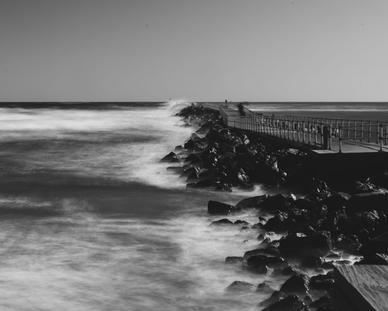
A pier or jetty changes how water leaves the surf zone. Waves push water onto the beach, and that water has to flow back out. On an open beach the return flow spreads across the sandbars. Next to a solid structure, the return flow concentrates along the structure because the wall is the easiest path. NOAA's Ocean Service describes this as a structural rip current, and the US Lifesaving Association notes it is one of the most consistent rip current setups on developed coasts.
The same logic applies to natural rock outcrops and reef edges. Wave-driven water flows toward them, hits the obstacle and squeezes through the gap. The gap becomes a narrow channel of fast-moving water that looks deceptively calm because the waves break on the rocks rather than in the channel.

What it looks like from shore
Three visual signals separate a structure rip from the water around it. First, a darker channel running parallel or angled to the structure: deeper water with less wave action looks darker. Second, a gap in the line of breaking waves next to the structure: waves do not break across the channel because the water is moving fast and is deeper. Third, foam, debris or seaweed steadily moving away from the beach in that channel.
These three cues are usually most obvious when the surf is moderate. A flat sea may not show them. Large surf may show them everywhere. The danger window is the in-between: enough wave action to drive the rip, not enough chaos to mask the channel. That is also when most casual swimmers think the conditions are fine.
- Darker channel near the structure (deeper water).
- Gap in the breaking line (waves do not break in the channel).
- Foam or debris drifting seaward beside the structure.
Sieve channels next to rocks
Sieve channels are narrow currents that run between two obstacles or through a small gap. A rock cluster on a sandy beach can produce a sieve channel right next to it whenever waves are breaking. The flow is not a wide rip; it is more like a focused jet, and a swimmer who drifts into it is pulled fast through the gap.
Reef passes work the same way at a larger scale. Tropical and Mediterranean rocky coasts are full of small sieves, and they catch swimmers who get curious about the rocks. The visual signal is similar: less wave action in the channel, water motion clearly going one direction, often a mix of foam and seaweed funneled through.
Why people end up at the structure anyway
There are practical reasons piers and rocks attract swimmers. The water beside a pier looks calmer because waves are partly blocked. Rocky outcrops shade a corner of the beach and feel more sheltered. Jetties and groynes seem to create a small protected pocket. All of those are real, but the protection is partial: the zone right next to the structure is often the rip channel, and the protected pocket may not be where you think.
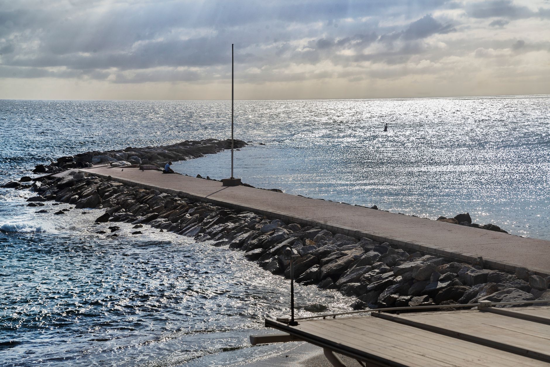
Lifeguards usually mark the safe zone with flags and place it deliberately offset from any structure. If there are no flags, the rule of thumb is to enter at least one or two pier-lengths away from a pier, and at least 30 to 50 meters from a rock outcrop. In larger surf, double or triple that.
- Lifeguarded beach: enter inside the flagged area, not next to the pier.
- Unguarded beach: stay 30 to 50 meters from solid structures in moderate surf.
- Stronger surf or longer-period swell: increase the buffer further.
What to do if you get caught
Most rescue advice is the same for structural rips and open-beach rips. NOAA's guidance is to stay calm, do not swim against the current, and either swim parallel to shore until you exit the rip or float and signal for help. The structural element adds one wrinkle: do not grab the structure during the rip. Pier pilings and rocks are sharp, often have biological coatings, and the rip flow against them can pin a swimmer.
If you can swim parallel to shore, swim in the direction that takes you away from the structure, not toward it. Once out of the channel, you can usually re-enter the surf zone where waves are breaking and let the broken-wave push help you back to shore.
Plan with the spot page
BeachFinder shows wave height, period, wind direction, water temperature and water quality on each spot page. None of those replace the visual check at the beach, but together they tell you when structural rips are most likely. Moderate to large surf, longer periods, plus a known structure equals a beach where the entry zone matters more than usual.
Use BeachFinder to compare the photo, map, weather, UV, water temperature, wind, waves, currents, water quality where available, amenities, stays and activities before committing to the trip.
출발 전 체크
- Identify any pier, jetty, groyne or rock cluster on the beach before entering.
- Look for darker channels, gaps in breaking waves and seaward foam drift next to structures.
- Stay at least 30 to 50 meters from solid structures in moderate surf, more in larger surf.
- Enter inside the lifeguarded flagged area when one is set up.
- If caught, swim parallel away from the structure, not toward it; do not grab pilings or rocks.
FAQ
Are piers always dangerous to swim near?
Not always, but they are statistically over-represented in rip current rescues. The structure concentrates the seaward return flow on at least one side, and that side is usually the rip channel. Stay clear of the immediate edge unless lifeguards have flagged the area, and double the buffer if waves are breaking.
Why do rocks create currents even on calm days?
On a calm day with no waves, rocks create much less flow. The current appears when waves break and push water that has to escape somewhere. The narrow gap beside or between rocks becomes the easiest path, and the jet through the gap is the sieve channel. The bigger the surf, the stronger the sieve.
Can lifeguards predict structural rips?
Experienced beach lifeguards know exactly where the structural rips are on their patch and place the flags accordingly. If you see flags, follow them. The rip is almost certainly in the unflagged zone next to the pier or jetty, by design.
BeachFinder로 오늘의 스팟을 확인하세요.
현재 위치, 전 세계 도시 검색 또는 지도를 사용해 주변에서 가장 관련성 높은 수영 스팟 20곳을 비교하세요.
These beach pages connect the guide advice with real spot details: sea temperature, wind, UV index, waves, access and photos when available.
Praia de Quarteira
PT
Playa de la Mata Negra
PT
Praia do Carvalho
PT
Plage Rive Gauche
FR
Plage de la Dalle
FR
Plage de Saint-Jean
FR
Praia dos Alemães
PT
Praia da Barra
PT
Plage du Lividic
FR
Lagoa de Albufeira
PT
Plage de Notre-Dame
FR
David
FR
Plage du Moulin Brûlé
FR
Praia dos Castelos
PT
Plage de La Folie Calette
FR